Reading the Ground: How Ground-Penetrating Radar Is Giving Voice to Enslaved Communities Buried by History
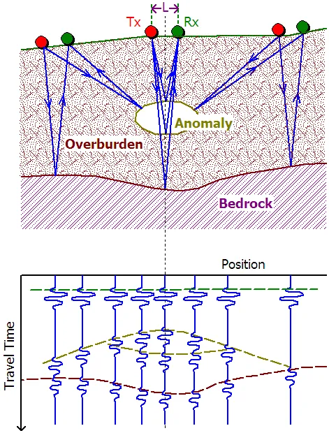
Photo: BacLuong at Vietnamese Wikipedia, Public domain, via Wikimedia Commons
For generations, the historical study of American slavery leaned heavily on documents produced by enslavers: ledgers, estate inventories, correspondence, and plantation diaries. These sources are not without value, but they encode a profound asymmetry. They record the names, ages, and market valuations of enslaved people with the same detached efficiency applied to livestock or equipment, while the interior lives, spatial arrangements, and material practices of those people remain largely invisible. Archaeology has long offered a corrective, but traditional excavation carries its own limitations—it is slow, expensive, and can disturb the very remains it seeks to study. Ground-penetrating radar (GPR) is changing that equation in ways that are reshaping plantation archaeology across the United States.
What Ground-Penetrating Radar Actually Does
GPR works by emitting pulses of electromagnetic energy into the ground and recording the signals that bounce back when those pulses encounter subsurface features—soil disturbances, structural foundations, voids, and buried objects. The resulting data, visualized as a series of two-dimensional cross-sections that can be assembled into three-dimensional maps, allows researchers to identify anomalies beneath the surface without removing a single shovelful of earth. For plantation archaeology, this matters enormously. Many burial grounds associated with enslaved communities were never formally documented; some were built over, plowed under, or simply forgotten as plantations transitioned through post-Civil War land tenure changes. GPR offers a means of locating these sites with a precision that earlier remote-sensing technologies could not achieve, and doing so in a manner that descendant communities—many of whom regard disturbance of ancestral remains as deeply problematic—can accept.
Case Studies Rewriting the Record
Among the most instructive recent projects is the ongoing archaeological work at Montpelier, the Virginia estate of President James Madison. Researchers working with the Montpelier Descendants Committee have used GPR to map what is believed to be a substantial enslaved-community cemetery on the property's south lawn, identifying dozens of probable burial shafts that were never recorded in any plantation document. The project is notable not only for its methodological rigor but for its governance structure: descendant community members hold meaningful authority over research decisions, including whether and how any physical excavation proceeds. That collaborative framework has become something of a model for the field.
A different set of findings emerged from work conducted at the Whitney Plantation in St. John the Baptist Parish, Louisiana, one of the few plantation sites in the country whose interpretive mission centers explicitly on the experience of enslaved people rather than that of the planter family. GPR surveys conducted there have helped refine the spatial layout of the slave quarters, revealing building footprints and activity areas that differ in important ways from the plantation's own historical records. The discrepancies are analytically significant: they suggest that enslaved workers exercised a degree of agency over their domestic space that the documentary record does not acknowledge.
In South Carolina's Lowcountry, researchers examining former rice plantations along the Combahee River corridor have used GPR in conjunction with LiDAR elevation data to identify what appear to be the remnants of enslaved-built irrigation infrastructure—an engineering achievement of considerable scale that has received little historical attention. The physical evidence on the ground tells a story about specialized knowledge, collective labor organization, and technological sophistication that contradicts longstanding assumptions about the deskilled nature of enslaved agricultural work.
Beyond the Quarters: Artifacts and the Material Culture of Resistance
GPR is most often associated with locating structural features and burial contexts, but its application in plantation archaeology increasingly intersects with the study of portable material culture. When subsurface anomalies identified by radar are subsequently excavated—with descendant community consent—they frequently yield objects that illuminate practices of spiritual life, resistance, and cultural continuity that enslavers had strong incentives to suppress and that the written record therefore rarely captures.
Among the most discussed categories of such finds are the so-called colonoware ceramics—low-fired earthenware vessels produced by enslaved African Americans and, in some coastal areas, by Native American potters—and the assemblages of objects sometimes referred to as "spirit bundles" or "mojo bags," which reflect the persistence of West and Central African religious practices in the American context. These items are not incidental curiosities. They are evidence of a parallel cultural world that enslaved communities maintained in the face of systematic efforts at erasure, and GPR's ability to locate them without destroying their depositional context has become a significant methodological advantage.
Centering Descendant Voices
The shift in plantation archaeology toward non-invasive survey methods has coincided with—and in some respects been driven by—a broader transformation in how the discipline engages with descendant communities. Organizations such as the African American Cultural Heritage Action Fund, administered by the National Trust for Historic Preservation, have invested substantially in projects that position descendants as co-investigators rather than passive stakeholders. This is not merely an ethical nicety. Descendant knowledge about oral traditions, family histories, and the locations of remembered cemeteries has repeatedly directed researchers toward subsurface features that purely data-driven survey strategies would have missed.
At the same time, the increasing visibility of plantation archaeology in public discourse—driven in part by the New York Times's 1619 Project and by renewed national attention to the legacies of slavery following the events of 2020—has created both opportunities and pressures for the field. Scholars are being asked to produce findings that are accessible to broad public audiences while maintaining the methodological standards appropriate to peer-reviewed research. GPR, with its capacity to generate visually compelling subsurface maps, has proven to be an effective communication tool in that context, making the invisible visible in ways that resonate with non-specialist audiences.
Methodological Limitations and the Path Forward
GPR is not without its constraints. The technology's resolution and penetration depth vary considerably depending on soil composition, moisture content, and the density of root systems—conditions that differ substantially across the range of plantation environments in the American South, Mid-Atlantic, and border states. Interpreting GPR data also requires significant expertise; anomalies that appear to indicate burials can sometimes be explained by natural soil variation or agricultural disturbance, and the consequences of misidentification are serious in contexts where descendant communities have a profound stake in the findings.
These limitations argue for the continued integration of GPR with complementary methods: magnetometry, electrical resistivity tomography, systematic surface survey, and, where appropriate and consented to, targeted excavation. The most productive plantation archaeology projects of the current generation are those that treat technology as one component of a broader methodological and ethical framework rather than as an end in itself.
What is beyond dispute is that the combination of improved remote-sensing capabilities and more equitable research partnerships is producing a substantially richer account of enslaved life in America than the documentary record alone could ever provide. The ground, it turns out, has been holding these stories for a long time. The discipline is only now developing the tools—and the institutional will—to read them properly.